
Add flat imagery to Mercator map databases in GEE 5.1.0
When you build a Mercator-based map database, you must build imagery projects specifically for use with Mercator-based projection (EPSG: 3857). However, with GEE 5.1.0, if you already have database imagery projects in the Plate Carrée projection (EPSG: 4326), you can reuse them for your Mercator-based map database using Mercator on the Fly. When disk space is a key consideration, you only need imagery projects in Plate Carrée projection for 2D flat, 2D Mercator, and 3D databases, reducing the storage requirements for your assets.
Mercator on the Fly converts a Plate Carrée-based imagery project into a Mercator-based imagery project when you create your map database in Fusion. When GEE Server hosts the published Mercator database, the server requests the Mercator on the Fly imagery project in the database and serves it with a Mercator projection. With some projections, you may see a reduction in serving speed when projecting a Mercator on the Fly imagery project. For more information about performance, see Mercator on the Fly Performance Data.
As you decide which type of imagery project to build, you will need to consider the projection types you need and whether disk space or serving speed is important. For 2D flat, 2D Mercator, and 3D databases, you can use flat imagery with Mercator on the Fly if disk space is a key consideration. However if serving speed is a key consideration, you should build both flat and Mercator imagery projects. The following table shows the decision matrix to guide you:
| Build projects/serve databases | Mercator | 2D flat and 3D | 2D flat, Mercator, and 3D |
|---|---|---|---|
| Flat imagery project | X |  |
Disk space is most important. Flat imagery projects used for all
database types, with Mercator on the Fly used to serve flat imagery for Mercator map databases. |
| Mercator imagery project | |
X | |
| Flat and Mercator imagery projects | |
|
Serving speed is most important. Flat imagery projects used for 3D and 2D flat
databases; Mercator imagery projects for Mercator map databases. |
Of course, if you are serving imagery only as Mercator map databases, you should only build Mercator imagery projects.
To add a flat imagery resource to a Mercator-based map database:
Select Asset Manager from the Tools menu. The Asset Manager dialog appears.
Select Mercator Map Tools (2D) from the Asset Manager toolbar. The tools for Mercator maps appear in the toolbar.
Click
 . The Map Database Editor appears with no
projects selected.
. The Map Database Editor appears with no
projects selected.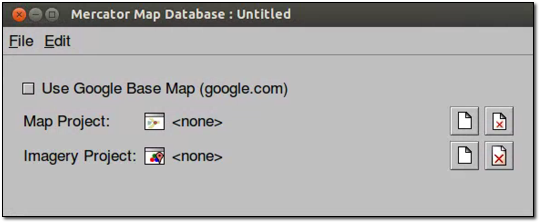
Click
 next to Map Project. The Open Asset dialog
appears.
next to Map Project. The Open Asset dialog
appears.Navigate to the
ASSET_ROOT/Projects/Mapfolder.Select the map project that you want to add to the map database and click Open. The map project appears in the Map Database Editor next to Map Project.
Click
next to Imagery Project. The Open Asset dialog appears.Navigate to the
ASSET_ROOT/Projects/Imageryfolder.Select Flat Imagery Project from the Type drop-down list, then select the imagery project to add and click Open. The imagery project appears in the Map Database Editor next to Imagery Project.
Select File > Save.
Navigate to the
ASSET_ROOT/Databasesfolder.In the Name field, enter a name, and click Save.
In the Asset Manager, the new map database appears, along with the other databases you have created. Notice that the Category column distinguishes between the Google Earth databases and the Google Maps database.
Right-click the name of your map database, and select Build from the context menu.
The status of the database immediately changes to Waiting or Queued and then to In Progress.
When Google Earth Enterprise Fusion finishes building the database, its Current State column in the Asset Manager changes to Succeeded, and its Current Version column changes to the date and time the most recent build was started.
Mercator on the Fly performance data
Mercator resolution increases relative to Plate Carrée as latitude increases (or decreases) from the equator for any given map level. Therefore to obtain the correct Mercator resolution, tiles must be sampled from higher Plate Carrée levels (known as upsampling). The higher the latitude, the greater the number of tiles required and, as a result, processing time for Mercator on the Fly increases (although not proportionally). The following table lists the number of Plate Carrée tiles required to produce a single Mercator on the Fly tile vs. latitude (north or south) and the approximate expected increase in processing time assuming cached tiles.
| Approximate Latitude Range(degrees) | Level Up to sample | MotF P.C. tiles processed | Max Relative Clock Time Ratio (relative to 1 tile) |
|---|---|---|---|
| 0 to 40 | 1 | 1-2 | 1 to 1.2 (2 tiles) |
| 40 to 65 | 2 | up to 4 | 2.1 (4 tiles) |
| 65 to 75 | 3 | up to 8 | 3.2 (8 tiles) |
| 75 to 85 | 4 | up to 16 | 5.1 (16 tiles) |
Learn more
Push and publish databases Make Web Map Service (WMS) requests